
This article is requiring no knowledge on Astronomy. It introduces, however, one of the most complicated concepts in astronomy: Astronomical Coordinates. It's then followed by some Glossary for terms including the words in original Arabic from which the English terms stemed and then a final 'test' piece in archaic Arabic by Ibn Khaldoun.
Now, many of those starting to learn Astronomy have a problem understading the difference between Equatorial Coordinates (Right-Ascention and Declination angles) and Horizontal Coordinates (Azimuth and Altitude angles). Here is some help.
Horizontal Coordinates
Ok! Forget about the stars now. You're standing in the night over a desert plain. Ahead of you is the North (you've used a compass to orient yourself). Around you is the 'circle' of the 'Horizon'! That's why it's called 'Horizontal Coordinates', because it takes the Horizon of wherever you'r standing as your 'reference' (=base or foundation) Ok?!
Now 'Azimuth' is the Compass angle around you and for every point at the 'Horizon' around you there's a degree number of its Azimuth like in the diagram.
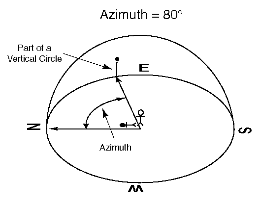
'East' at your right is the Azimuth of 90° (pronounced ninty degrees). South is 180° and North is 0° but also 360°. here's a diagram to help see this:
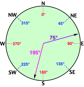
For those interested in navigation, we call this Azimuth angle measured by compass 'Bearing'.
'Under' each star you can see in the sky, there must be a point on the horizon that you can measure its 'azimuth', but what about the 'vertical' angle: Altitude angle?

now that's one thing a compass cannot measure. 'Astrolabe' and 'Sextant' is what we use here. I prefer Astrolabe because Sextants are designed for sea navigation and needs mathematical corrections for their measurements overland (or the mercury/water trick). Astrolabes need nothing. Whatever they read with their alidad (the arm you adjust to point towards the star) is your Altitude angle and that's it!


Now I think Horizontal Coordinates for the sky is clear. (no? :)
I have to add here that in equations Altitude angle has a symbol of (a) and Azimuth has a symbol of (h), or sometimes (A).
Now to finalise this.
At the top of your head is the 'Zenith'. This is simply the point at your head exactly or in our numbers Altitude of 90°. We like to say look at your Zenith instead of saying look at your Altitude of 90°. That's all. It's just cool and feels like you're becoming an astronomer when you use those strange words! :)

For every star you are told to look for in the sky, you should be given an Azimuth angle (from 0° to 360°) and an Altitude angle (from 0° to 90°). when you're given those numbers you use them quickly since stars move and a star doesn't wait in a position of azimuth and altitude except for few seconds. That means of course that every star has different Horizontal Coordinates at different times.
Not only that, but if you are watching say from Cairo and Casablanca, Morocco at the same second of time, then you will not have the same star at the same Horizontal Coordinates.
Imagine that Horizontal Coordinates are like a Glass Dome--marked with lines crossing it (say every 10th azimuth and every 10th altitude). You carry it with you and put its head towards North everywhere you go then look through it at the stars travelling from one of its line to another. Stars will move from one meridian (lines of same azimuth) to another in their travel during the night across your dome.
I will try in a later email to explain the Equatorial (Celestial) Coordinates. Btw, they have "Right-Ascention" (symbol ل =alpha in equations) and "Declination" (symbol ن =delta in equations) that works almost exactly like Horizontal Coordinates.
You'll probably never need to do mathematics to play with astronomy (that's what the software is helping really with). But if you're aware of the two systems and want to see how to do the conversion yourself (here's some mathematics for you or rather trignometry), check out those examples:
http://star-www.st-and.ac.uk/~fv/webnotes/chapter7.htm
http://www.shef.ac.uk/physics/people/vdhillon/teaching/phy105/phy105_celsphere_problems.html
Equatorial Coordinates
Now imaging you're standing exactly at the North Pole. Ok?! Is that hard to image? It's cold ok and it's night (winters there have 6 months of night you cannot fast Ramadan at all!!!!)
Earth is spinning under you (going to your left or anti-clockwise when your standing on it). Exactly at your 'Zenith' (overhead) there will be the star we call 'Negm elShamaal' ('Polaris' in English or 'North Star'). Because Earth is rotating under you one turn every day (360° every 24 hours), if you wait enough without any motion looking at the stars above, you'll feel as if Earth is not moving while the stars are turning around the North Star (clockwise of course). If you capture their motion in a photo the dots will make lines (curves) because of long film exposure and it would look like this (thanks Weam):

Now the whole dome of sky around you moves as one piece. Their globe are forever inscribed by those dots and feel as if rotating endlessly around our Earth. [remember that the stars don't move, but it's Earth's own movement around an imaginary line going through North and South Pole.]
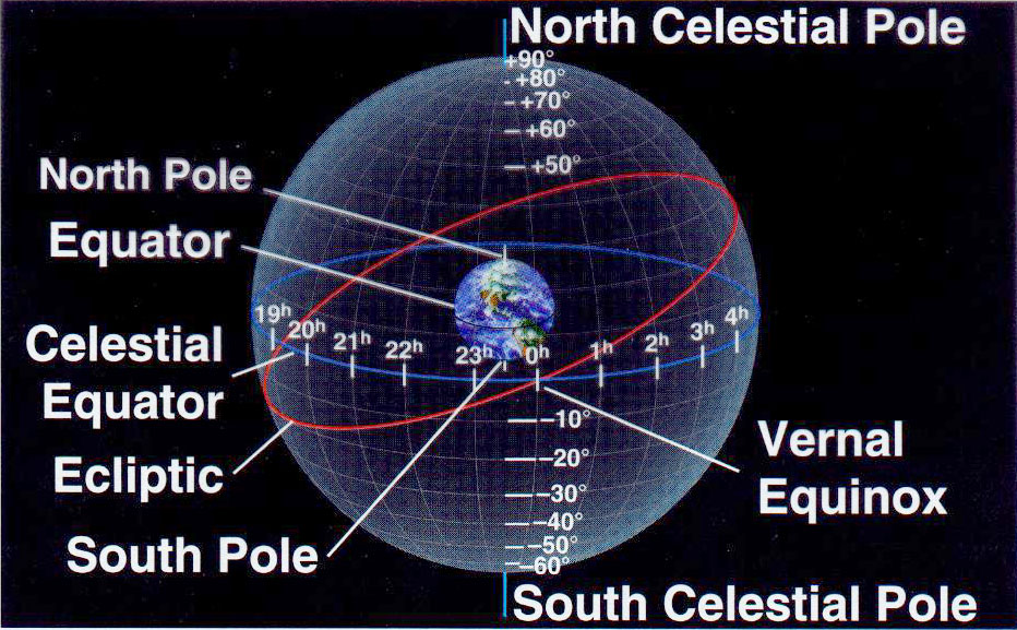
To make things easier, we'll just imagine that the stars that we see are not bodies but dots on a globe/ball surrounding Earth. Ok. this is important now because we're going to give this globe/ball/sphere a name and use it from now on: Celestial Sphere (Al Korra Al Samaweyah)

This rotating black globe of stars is called the "Celestial Sphere" and it's positioned as if Earth is at its centre. It has what is called North Celestial Pole (NCP) that is exactly at the 'Zenith' of our North Pole at Earth. Also South Celestial Pole (SCP) at Zenith of our Earth South Pole. And --of course--"Celestial Equator":

This huge globe around us now needs to be marked by lines so that we can measure things on it and can locate the stars. Right? Coordinates ya3ni :)
 Coordinates are cool because you can read just two numbers in a book and you can use them in the field to find the Star! No need for any preivous experience of the star (or galaxy or nebula). That's damn cool!
So we measure an angle paralellel to Celestial Equator and call it "Right Ascension" (RA for short and similar to "Azimuth" of the Horizontal Coordinates) and the other along meridians (khotout eltool) called "Declination" as in this diagram to your right here.
In CSKY software, you can show the Equatorial Coords grid by clicking on the E button near the bottom of the screen.
THAT'S ALL! :) Now you know everything about the Equatorial Coordinates.
Oh. I forgot to say that instead of 360° numbering for the RA, we use 24h numbering. Of course (like you remember from the 'Altitude' angle of the Horizontal Coordinates) that 'Declination' is measured as 0° at Celstial Equator and 90° at the Celelstial Pole.
Few things that use Equatorial coordinates that we have to mention. They help making it more clear.
EARTH'S TILT--EARTH'S TILT--EARTH'S TILT--EARTH'S TILT--EARTH'S TILT--:
=======================================
the imaginary line that Earth spins around (called axis or Me7war in Arabic) is tilted (mayel). The Earth is like a gyroscope ('el-na7la' beta3et el3eyaal) once it stars spinning it keeps its axis at the same angle. so Earth's axis is 23.5° angle from the vertical. Now remember that Earth's goes around the sun once every year! Notice the dates.

Think of it. It should be clear now that if the Celestial Sphere of the stars have everything in it fixed in their 'permanent' RA and Declination (coordinates) the sun will seem to be going in a line. Because the Earth's tilted axis, the sun's path will be sometimes over the Celestial Equator and other times under it. Right? (ya right! well 'ask' if you don't get it :) Well that's the next part.
ECLIPTIC--ECLIPTIC--ECLIPTIC--ECLIPTIC--ECLIPTIC--ECLIPTIC:
======================================
Earth is tilted but to see things right, we'll put its axis straight up again like this:

and the line of the path of the sun (one round every 365 days) is called the Ecliptic line.
In CSKY software the ecliptic is a green line that you can show or hide by a button at the bottom of the screen.
IMPORTANT FACT: All planets with no exception always move very close to the Ecliptic line and never very far from it. All their moves are on this line as you can see in the CSKY when you animate it.
VERNAL EQUINOX (E3TIDAAL RABI3EE)--VERNAL EQUINOX (E3TIDAAL RABI3EE):
=========================================
The Ecliptic cuts the Celestial Equator at two points that are Very important because they mark the seasons on Earth. The two points are called: "Vernal Equinox" and "Autumnal Equinox".

The first one (Vernal Equinox) is the point chosen on the Celestial Equator to mark the begining of any measure of RA (Right Ascension). Also, when the sun reaches this point it's at the exact date of March 21 (I think). The lowest and highest points of the Ecliptic --of course-- are for Winter and Summer 'Solstice' ('Enqilaab Shetwi' and 'Enqilaab Saifi' in Arabic and they're at the exact dates of December 21 and June 21 respectively).
Fore more on the Celestial Sphere and the Equatorial Coordinates (and different views of it), you can try:
After all, I cannot explain it all on my own in those simple emails :) To help me even more, ask questions on SSC and I'll try to explain.
Here's something that is more than just decoration if you are becoming proud of your knowledge and wish to show it off in your home:

they're real Celestial Sphere models but .... a bit expensive! :)